


DeepAqua
Objective
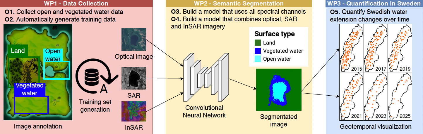
The main purpose of the DeepAqua project is to quantify the changes in surface water over time. We want to create a real-time monitoring system of changes in water bodies by combining remote sensing technologies, including optical and radar imagery, with deep learning techniques to perform computer vision and transfer learning. Employing this innovative strategy will allow us to calculate the water extent and level dynamics with unprecedented accuracy and response time speed. This approach offers a practical solution for monitoring water extent and level dynamics, making it highly adaptable and scalable for water conservation efforts.
Background
Climate change presents one of the most formidable challenges to humanity. In the current year, we have witnessed unprecedented heatwaves, extreme floods, an increasing scarcity of water in various regions, and a troubling surge in the global extinction of species. Halting the advance of climate change necessitates the preservation of our existing water resources. However, recent advancements in remote sensing technology have yielded a wealth of high-quality data, opening up new avenues for researchers to leverage deep learning (DL) techniques in water detection. DL is a machine learning methodology that consistently outperforms traditional approaches across diverse domains, including computer vision, object recognition, machine translation, and audio processing.
This project, named DeepAqua, seeks to enhance our understanding of surface water dynamics and their response to environmental changes by developing innovative DL architectures, such as Convolutional Neural Networks (CNN) and Transformers, designed specifically for the semantic segmentation of water-related images. It is worth noting that many DL models depend on substantial amounts of ground truth data, which can be costly to obtain. Our previous findings suggest that we can train a CNN using water masks based on the Normalized Difference Water Index (NDWI) to detect water in Synthetic Aperture Radar (SAR) imagery without the need for manual annotation. This breakthrough promises to have a significant impact on water monitoring since generating data based on NDWI masks is virtually cost-free compared to traditional methods involving fieldwork data collection and manual annotation.
Crossdisciplinary collaboration
The researchers in the team represent the Division for Water and Environmental Engineering (SEED/ABE), the Division of Software and Computer Systems (CS/EECS), KTH, and Stockholm University.
Contacts
Zahra Kalantari
Associate Professor in Environmental and Engineering Geosciences at KTH, Co-PI of project Optimization of Agricultural Management for Soil Carbon Sequestration Using Deep Reinforcement Learning and Large-Scale Simulations at C3.ai DTI, Co-PI of project DeepAqua, Digital Futures Faculty
+46 8 790 86 93zahrak@kth.se
Amir Hossein Payberah
Associate Professor, Division of Software and Computer Science at KTH, Co-PI: DeepAqua, Former Co-supervisor: Deep Wetlands, Digital Futures Faculty
+46 72 554 40 11payberah@kth.se